Ponds Field Day - 10/31/18
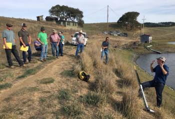
UCCE Marin County Director David Lewis and Ag Ombudsman Vince Trotter reviewed the terms of SB 88, how it applies to ponds around Marin County, and the steps ranchers can take to comply. We also visited two ranches to see different equipment that satisfies the requirements of SB 88 and talked through alternatives that other ranchers could try.
To understand how your pond fits with SB 88, see the key terms and table below. Also on this page are descriptions of the systems we reviewed during the 10/31 field day. For each ranch, you will find detailed descriptions of the equipment we discussed, how it was installed, the vendors, costs and even alternatives.
Key Terms
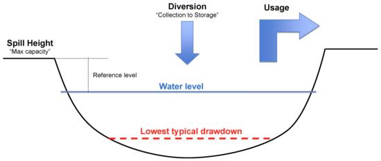
- Usage: The portion of your diversion that is put to use, e.g. watering livestock, or irrigating crops. Think of it as water EXITING your pond.
- Reporting: The process of providing data to the state water resources control board collected over the course of a calendar year, detailing the amount of water diverted and used every month. SB 88 requires that all water right-holders report annually using the state's online eWRIMS Report Management System (RMS). Licenses, Registrations, Statements of Use and Stockpond Certificates all file their reports by February 1st.
- Measuring: The process of collecting data at regular intervals so that you can accurately represent how much water was diverted and used every month. SB 88 requires that ponds that have a face-value diversion of more than 10 acre-feet must install equipment that meets specific standards for accuracy and frequency of data-collection.
- Face-Value: The amount of water (acre-feet) that a pond is allowed to collect over the course of a year. See your actual license, registration, statement or stockpond certificate to find the face-value for your water right. Even if drought or other circumstances prevent you from collecting the full amount of water into your pond, the Water Board judges your place in the regulations for SB 88 based on the face-value.
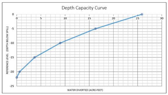
DWR@waterboards.ca.gov and request the "field file" for your water right. Mention that you specifically need survey data and/or a depth capacity curve.
Failing this, you can do your own survey and generate a curve using a staff gauge, some simple equipment and an online app developed by UC Cooperative Extension.
Click here to get instructions for generating your own depth capacity curve.
- Spill Height: A fixed point at the edge of the pond where water begins pouring out once the pond reaches maximum capacity. For some ponds, this is a concrete spillway, for others it is an outlet pipe or just a low spot in the pond perimeter. This corresponds with what is often called the “high water mark.”
- Lowest Typical Drawdown: The lowest point the water level drops to in a typical year. I.e. The minimum water level you would normally expect to see in the pond.
- Reference Level: The difference between water level and spill height at any given time. E.g. if the water level is 3 feet below spill, reference level is -3. If next month the level is 4.5 feet below spill, the reference level has changed by -1.5 feet. To translate these changes in reference level to acre-feet of water, use your depth capacity curve. Find the number of acre feet stored at -4.5 feet on the curve and subtract that from the acre-feet at -3. This is how many acre-feet of water went out of the pond over the past month.
SB 88 Explained
No matter who you are or how small your pond, your usage (water flowing out) must be tracked on a monthly basis. There are no requirements for the method you choose to measure this usage as long as a reasonable effort is made to arrive at an accurate number. You can install a flow meter to track the gallons flowing out of the pond via a pipe, or you can simply calculate usage based on the number of animals watered from the pond, the number of hours a pump operates, or the number of times a tank is filled.
However, diversion (water flowing in) is carefully regulated under SB88. Depending on the size of your pond, you may need to take measurements more (or less) frequently and with a specific degree of accuracy. You may need a licensed expert to install the equipment. And when filing your report, you will need to describe the equipment used to measure the diversion including manufacturer, serial numbers, etc. and even attach the raw data from your measurements along with your report.
To know how YOU should be measuring your diversion, consult the table below based on the face-value amount on your water right:

A Note on Reporting...
All water right-holders must now file annual reports to the Water Board using the online system eWRIMS Report Management System (RMS). Reports must include monthly numbers for 1) your diversion and 2) your usage from October 1 through September 30 of the following year. Reports for all types of diversion (licenses, registrations, stockpond certificates, statements of use) are due by February 1st.
To help you calculate and record your monthly numbers, download this spreadsheet, created by UCCE Marin. Within this one document, there are worksheets to calculate diversion if:
- You’re tracking diversion with a staff gauge, OR
- You’re tracking diversion with a laser level
As well as worksheets to calculate usage if:
- You’re using the number of animals watered to track usage, OR
- You’re using a flow meter to track usage.
If you need help filing your online annual report, you can contact Vince Trotter, Agricultural Ombudsman at UC Cooperative Extension, Marin, and set up an appointment to get assistance. Contact Vince at tvtrotter@ucanr.edu, or (415) 473-4204. Simply bring the data you have collected and we will help you navigate the system.
Ranchers whose land is protected by a MALT easement can also contact Eric Rubenstahl, Associate Director of Stewardship, for assistance filing your annual report. Contact Eric at erubenstahl@malt.org, or (415) 663-1158, ext. 319.
Making it work
We visited 2 ranches to see how each is meeting the requirements of SB 88. A third ranch is still in the process of installation...
Ranch 1
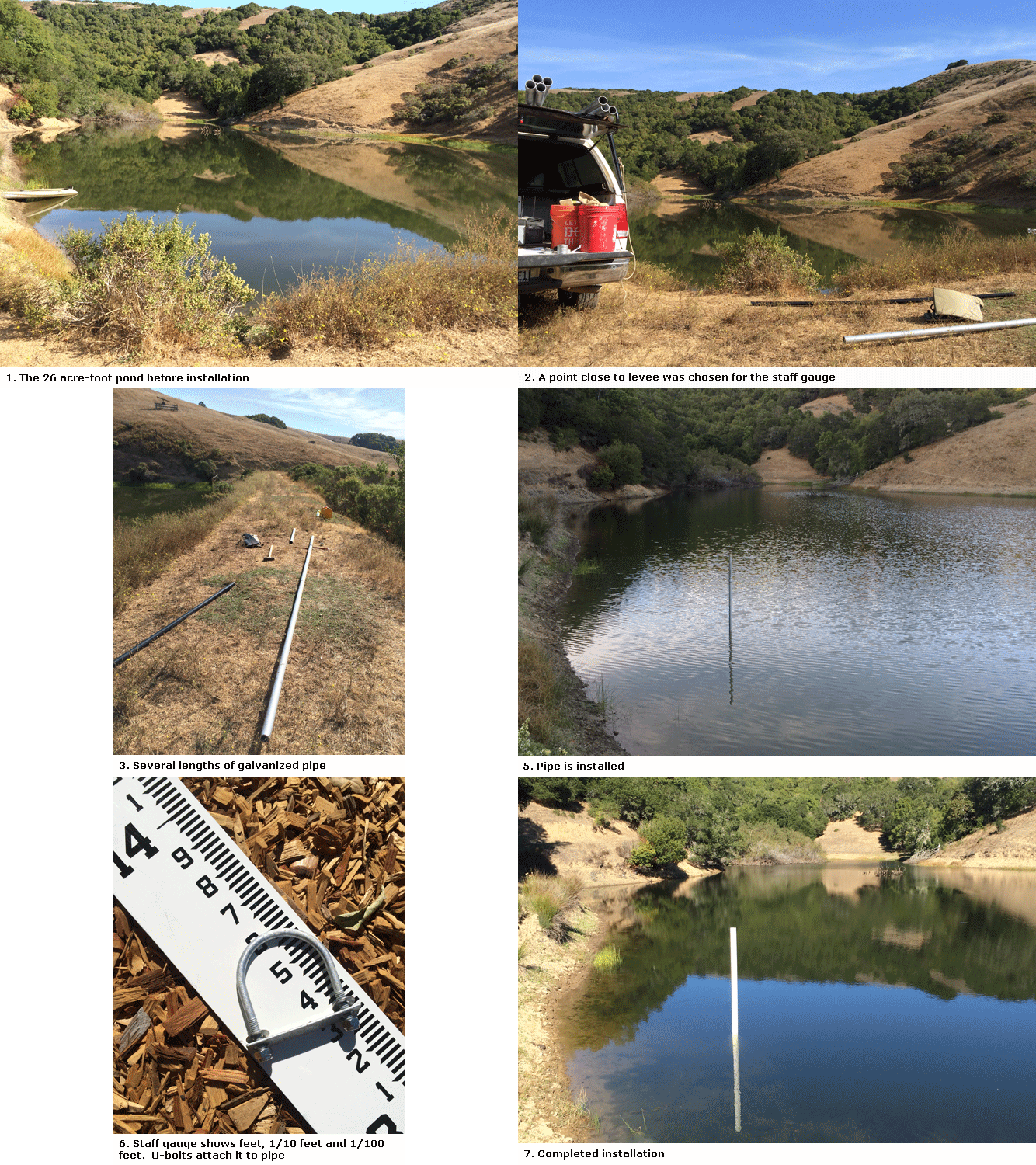
This 26 acre-foot pond has one line out pumping to livestock tanks. DIVERSION (water flowing in) is measured monthly by noting the water level on a staff gauge and recording changes in a datebook. When the water level rises from month to month, that constitutes DIVERSION. The number of acre-feet collected during this period is found by consulting the depth capacity curve. Months when the water level does not change or goes down are recorded as a diversion of 0 acre-feet.
USAGE is tracked by recording the number of head watered each month, multiplied by the average rate of consumption per head. The staff gauge can also be a method for tracking usage. When water level goes down from month to month, the drop is translated into acre-feet using the depth capacity curve and recorded as usage. Months when the water level goes is unchanged or rises, usage is 0 acre-feet.
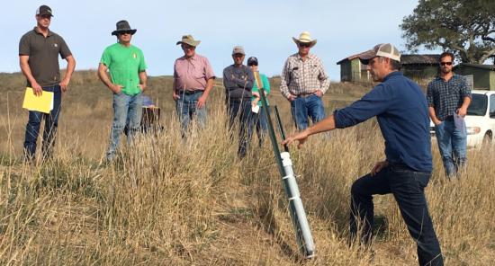
The staff gauge is mounted on 2” galvanized pipe using galvanized u-bolts and stainless steel nuts/washers. Lowest typical drawdown is 10 feet below spill, so the pipe is placed at a point on the pond floor almost 11 feet below spill height. A location close to the pond approach that would be easy to read from shoreline was preferred. The pipe is pounded 5 feet into the pond floor with 12 feet standing above the floor. A laser level was used to mark spill height on the pipe. In the case of this pond, spill height hits the staff gauge at 10.7 feet.
Water level is recorded monthly in a datebook and subtracted from 10.7 to establish the reference level for the pond at that time. Changes in reference level from month to month can be tracked on the depth capacity curve to know how many acre-feet flowed into or out of the pond.
See full details on installation, pricing and alternative methods here.
In lieu of a staff gauge, one alternative method for getting accurate measurements on a monthly basis is to use a standard construction laser level placed at spill height and measure with a tape or staff from the laser down to the water level once each month. This method is considerably easier to install than a staff gauge and you may already own a suitable laser level for other projects. You can see details on using this method in conjunction with your pond's depth capacity curve here.
Ranch 2
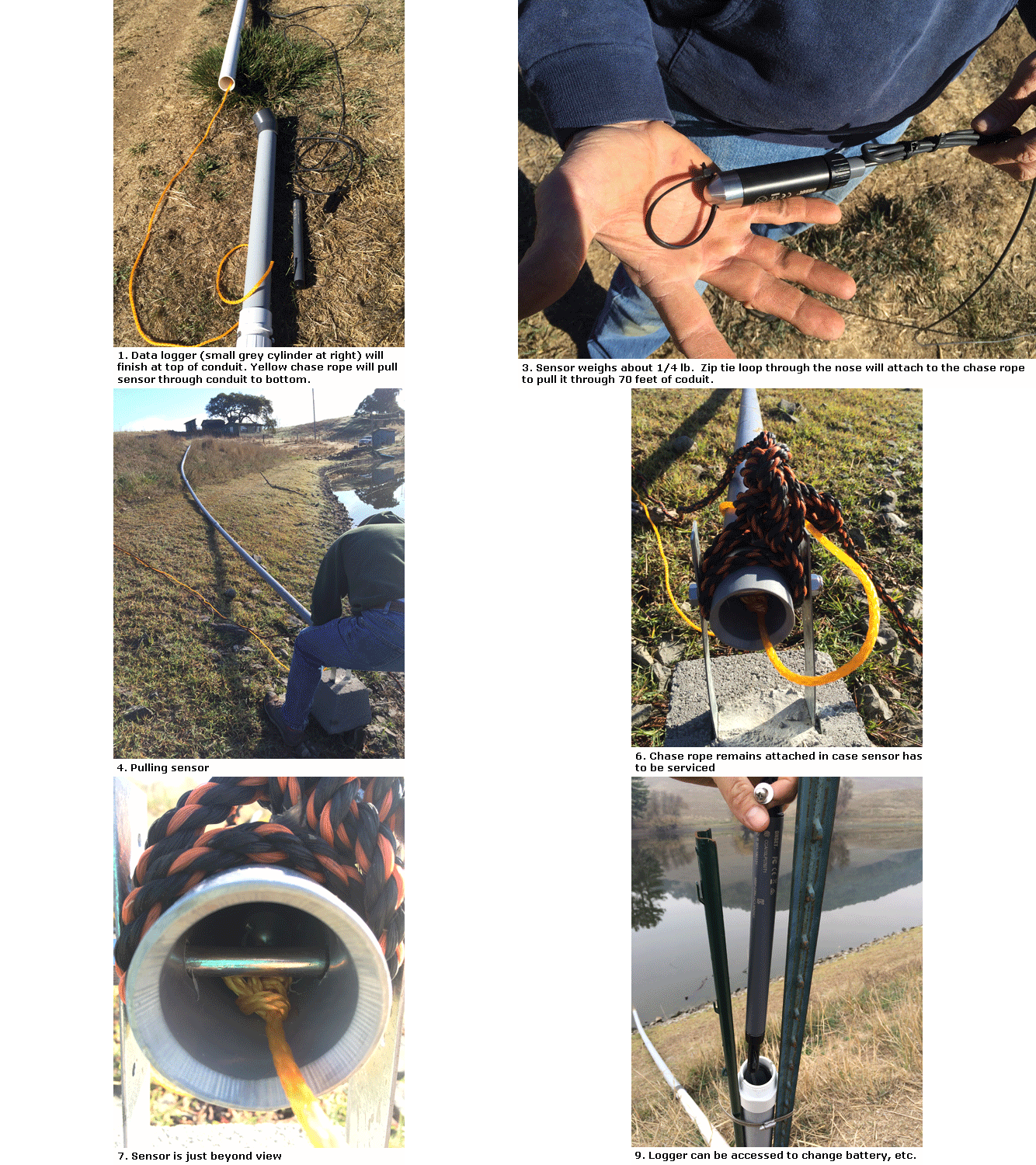
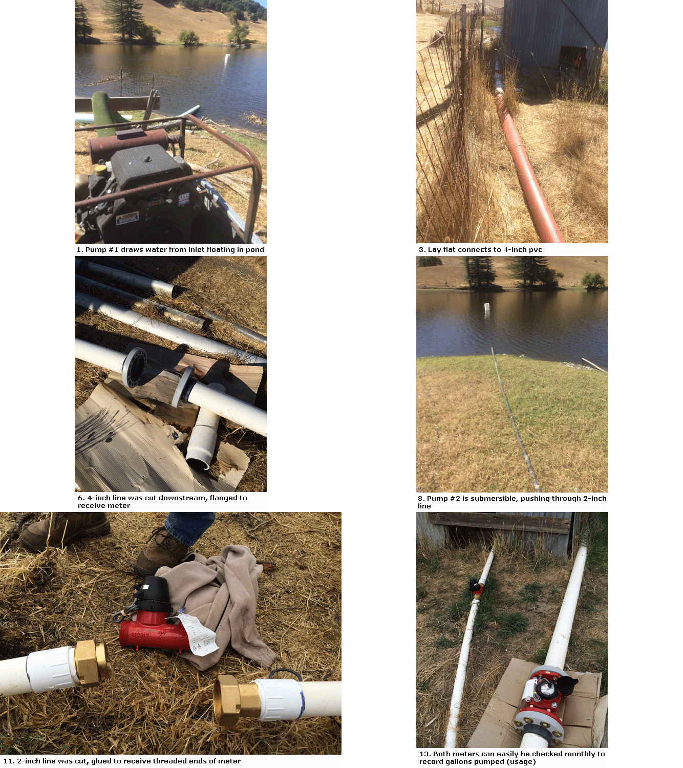
This 70-acre foot pond has two lines out, each pumping separately to a dairy/livestock tanks and row crops. DIVERSION must be measured weekly, so rancher uses a depth transducer (water level sensor) which remains submerged year-round at a spot marked by a buoy. The sensor records the reference level every 18 hours and this information can be uploaded to the rancher’s phone at any time by standing within 100 feet of the device. Changes can be translated into acre-feet using the depth capacity curve.
USAGE is tracked by flow meters installed on both lines pumping out from the pond. Rancher records total flow monthly in a datebook and subtracts from month to month to establish how many gallons were used.
The pressure transducer is protected inside 2” pvc conduit that is anchored at a point on the shore, above high water mark, and extends 70 feet out into the pond. Holes drilled in the pipe allows water to flow freely in the pipe. Concrete footings hold up the pipe, keeping it off the pond floor to avoid sediment collecting in the pipe and interfering with measurements.
Lowest typical drawdown is 15 feet, so the sensor sits at a point nearly 18 feet below spill. A cable traveling back up the conduit to the shore end of the pipe carries data from the sensor to a data logger that sits inside a final, upright length of pvc. At reporting time, the rancher can connect to the data logger via bluetooth signal, upload all changes in water level for the year and convert those changes to acre-feet using the depth capacity curve.
See full details on installation, pricing and alternative methods here.
Measuring diversion:
Measuring usage:
Ranch 3 (not visited during 10/31 field day)
This 70-acre foot pond has one line out which splits downstream to water cattle and irrigate row crops. DIVERSION must be measured weekly, so rancher will use a depth transducer (water level sensor) suspended from a dock which extends out into the pond. The pressure transducer is protected inside 2” pvc pipe that is attached to the dock, extending down below the point of lowest typical drawdown, nearly 40 feet below spill. A cable carrying data from the sensor travels from the dock, inside buried conduit over the levee and down dam face to a data logger 400 feet away.
The sensor will record the reference level every 18 hours and this information will be stored on the data logger. Data can be uploaded do a laptop, and changes over time can be translated into acre-feet using the depth capacity curve.
USAGE is tracked by a flow meter on the outlet pipe. The meter is connected to the same data logger, storing usage information alongside diversion data.
At reporting time, the rancher can connect a laptop to the data logger and upload changes in reference level and flow for the entire year. Using the depth capacity curve, rancher can establish monthly increases in water stored over the rainy season.
See full details on installation, pricing and alternative methods here.
Additional Resources
- California State Water Resources Control Board, Reporting & Measurement Information
- California State Water Resources Control Board, Reservoir Storage Measurement & Recordkeeping Guide
- California State Water Resources Control Board, Online Report Management System (RMS)
- UC Cooperative Extension, Marin County factsheet for Registering Your Marin County Farm Pond


